About oshtorankoh
Lorestan province at about 28,064 square miles
from north to the central province of Hamedan, Hamedan province to the East,
the West provinces of Kermanshah and Ilam and Khuzestan province to the south
is limited. Based on the 1381 political subdivision of the
Zagros mountain range in West Iran between 46 and 51 degrees to 50 degrees and
3 minutes east of the Greenwich meridian and 32 degrees and 34 degrees 37
minutes 22 minutes Contract.
Lorestan is a mountainous area
with high peaks and deep valleys and snow in the mountains that often there is
a vast pastures. The
province has Mshjr slopes and oak rainforests that impassable mountains and the
vast landscape of interest is forgiven. Mountain weather and snow in winter and
summer in temperate areas and plains and hot summers winters
are mild. This
ancient land of the province, a beautiful and pleasant weather with water and
surrounded by high mountains and impassable middle part of the Zagros Mountains
series) Central Zagros (is.
Lorestan province with varied
climates. The
variation from north to south and from East to West is quite tangible. When
winter snow and ice storm in northern Lorestan continue with the southern parts
of air conditioning and has sprinkler. Western
sectors such Sfydkvh than eastern parts, namely peace and Aligudarz, descending
is more atmospheric. Variability
of climate in the province can be seen clearly so that the moderation
Khorramabad winter and summer heat, winter cold and moderation Borujerd summer
and very cold climate Aligudarz of winter and temperate summer Brkhvrdarast.
Causes of climate variability
Lorestan include:
- Position of the Zagros
Mountains to the west to humid winds
- High altitude above sea level
in this area
- Compaction mountains
- Located in the middle latitude
- Effects of hot winds of the
South so that the absolute difference between the maximum and minimum
temperatures over 80 degrees
The maximum temperature recorded
at least 47 and the absolute temperature registered 35 - C is reached.
Generally identified three
regions in Lorestan climate is seen:
* Cold mountainous region of
snow and very cold winters and mild summers there. Parts
of this region in the north, northwest and east of Lorestan is located. Number of frost days in some parts of the area to reach
more than 70 days. The
first detachment of this region with a long winter begins and spring and fall
short in this area. Boroujerd
areas, Doroud, Azna, Aligudarz, Norah Long, and Alashtar more than 1400 meters
have this climate are having.Gohar Lake and the major part of
Oshtorankooh protected area in this region is located.
* County Central Mtdl the
intermediate mountainous area north, North East and South District Post
province, due to lower altitude, atmospheric loss for the winter and spring
rains and frost occur rarely. Spring in the area of the Persian month Esfand started in early May due
to increased heat, summer is starting earlier; Khorram Abad and around with
this kind of weather is.
* G regions southern province
that has the minimum height due to the effect of hot winds and low Khuzestan
latitude and high altitude being the maximum temperature in summer is having. Rainfall in this area reaches its minimum. Pldkhtr and Papi with this kind of weather that the harvest of
agricultural products a few months earlier than other areas of the province
begins.
Annual rainfall in Lorestan
province on average between 400 to 450 mm fluctuate.
Lorestan province in terms of
climate and weather is a province of four seasons. When
winter snow and ice storm to the north of Lorestan and severe winter
encompasses the southern part of the air conditioning and has a sprinkler and
southern parts it had when it is warm northern areas of the province have a temperate
climate.
Khorramabad with mild winter and
hot summer and cold winter and summer Boroujerd is moderate.
Aligudarz, Noorabad, Alashtar
also have cold winters and mild summers are
Oshtorankooh region and its
history:
Protected area in terms Oshtorankooh
divisions in Lorestan province city of shielding Vhvz·h Hello, Azna and has
Aligoodarz but its management is located in the city of peace and it is run
through. Oshtorankooh
protected area since 1346 and declared as protected area equivalent in IUCN
protected area categories are class IV.
- The extent Oshtorankooh area:
54,440 ha
- In the range of Lorestan
province
- Doroud city area Tuesday, and
Azna Aligudarz
- A geographical position 28 °
49 - A long 58 ° 48 East
A 35 ° 33 - A North latitude 11
° 33
Changes in land elevation 4050 -
1300 meters above sea level
The average height of 2365
meters above sea level
Height with the highest
frequency 2000 - 1900 meters above sea level
Mountainous region with steep
slopes are lands with.
Weighted average slope lands 9 /
45 percent
Slope lands with the highest
frequency of 65-30 percent
History Zone:
Considering the importance of
the region in 1340 with the name of the area grazed Tyvn exclusive, hunting was
banned, including mountain and valley Oshtorankooh Ga straw was the ban
continued until 1346 and this year the organization and supervision of fishing
time Shkarbany dedicated grazed Tian
(Tyvn) by adding white mountain heights, large and small, large and small
mountain outlet, Gzrsvn, green, flat goods, Asynh, large and small wind Gvlk
Gchh and 93,950 hectares of protected area declared protected area and name Oshtorankooh
on that institution. In
1357 changes in the limits of areas including the region, White Mountains big
and small and isolated area as wildlife sanctuary and conservation area was
also added Oshtorankooh Nsar mountains separating roll and part of the
Southeast Heights and
East region with an area of 54,440 hectares as current
income.
Regional animal species:
Wildlife and fauna, a protected
area for the most important potential sources of capital and is considered
Oshtorankooh protected area in the Zagros Mountains area, cold chain and
located in the area of animal classification
areas in 1911, presented by Zarvdny , as the Fifth District of animals are listed.Meanwhile, the region of divided
regions in the animal world Rktyk Contract Palh area. Oshtorankooh wildlife conservation area affected dry climate and
cold mountainous northwest and semi-humid temperate Lorestan province is the
center. Entirely mountainous topography of the region also has direct
effects on the wildlife it.
Mammals of the huge animal
species in the mountain area index can lead to species such as goats and sheep
ram Carpa aegagrus Armenian Ovis gmelinii, Leopard. Panthera
paradus door of Quebec birds Tetraogalus caspia, partridge, Alectoris chukar
Kelly is back and hunting is Sittidae Raptors and the fish can be spotted trout
and rainbow trout red pointed.
Climate and weather, soil and
earth structure in the region, the physical environment of the province, has
founded the environmental cause that certain biological diversity of plant and
animal has a remarkable. Lorestan province confirmed the presence of 21
species of mammals that 15 percent of mammals in the form but the species is
low population density. Supported by three
species of mammals, 18 species are non-supported. Drfhrst species recorded in
the Red Book (Red DataBook of IUCN2004) Caprea aegagrus goats and rams and
sheep Ovis gmelinii Armenians are leopard Panthera pardus, and the wolf species
Canis lupus in the list of 1994 IP Yu CNN was recorded in 1994
but has been removed from the list. Populations
of these species in recent decades in Iran, therefore the sharp decline in
Lorestan province has had. In past decades around the lake habitat of these
species was Gohar, but now it can not be easily observed.
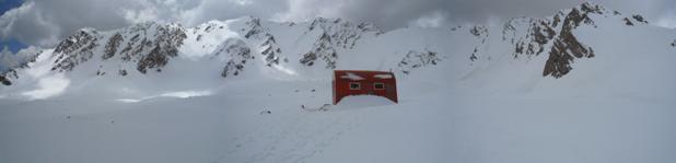
The highest point is a peak named San-Boran(4150m)
or Oshtoran Kooh. Oshtoran Kooh has east and west faces that are totally walls,
cliffs, rock routes and banded rock blocks which brings an impressive
challenge, anyway the east face is easier and the route to San-Boran and nearby
peaks is the easiest, the others peaks like Kool-e-Jennoo(3980m) are harder and
need technical climbing knowledge. Another feature of the area that makes
Oshtoran Kooh one of the favorites of Iranian mountain climbers is the
beautiful south face with two lakes named Small Gahar and Big Gahar being great
for camping.
The lakes, with a span of about 100 hectares, a length of 2500 meters, a width
of 800 meters, and a depth of about 28 meters is situated 2400 meters above sea
level.
استان لرستان در حدود ٢٨٠٦٤ کیلومتر مربع وسعت دارد که
از جانب شمال به استان مرکزی و استان همدان ، از شرق به استان همدان ، از غرب به
استانهای کرمانشاه و ایلام و از جنوب به استان خوزستان محدود است . براساس تقسيمات سياسي سال1381 در دامنه كوه هاي زاگرس در غرب ايران بين ٤٦ درجه و ٥١ تا ٥٠ درجه و ٣
دقيقه
طول شرقي از نصف النهار گرينويچ و ٣٢ درجه و ٣٧ دقيقه تا ٣٤ درجه و ٢٢ دقيقه قراردارد .
استان لرستان منطقه ای است
کوهستانی با قلل مرتفع و پر برف و دره های عمیق که در اغلب کوههای آن مراتع پهناور
وجود دارد . این استان دارای دامنه های مشجر و جنگلهای انبوه بلوط است که به
کوههای صعب العبور و سترگ آن منظره ای جالب توجه بخشیده است .آب و هوای مناطق
کوهستانی در زمستان سرد و پر برف و در تابستان معتدل و در نواحی جلگه ای تابستان
ها گرم و زمستان ها معتدل می باشد . اين استان سرزميني باستاني، زيبا و با آب هواي دلپذير
و
محصور در کوه هاي مرتفع و صعب العبورِ بخش مياني سلسله جبالِ زاگرس )زاگرس مرکزي( مي باشد.
استان لرستان داراي آب و هواي متنوعي است. اين تنوع از شمال به جنوب و از شرق به غرب كاملا محسوس مي باشد . زمستان هنگامي كه در شمال لرستان برف و كولاك ادامه دارد قسمتهاي جنوبي آن داراي هوايي مطبوع و باراني است. بخشهاي غربي مانند سفيدكوه نسبت به قسمتهاي شرقي، يعني درود و اليگودرز، نزولات جوي بيشتري دارد. تنوع آب و هوايي در شهر هاي استان بوضوح مشاهده مي شود بطوري كه خرم آباد از اعتدال زمستاني و گرماي تابستاني، بروجرد از سرماي زمستاني و اعتدال تابستاني، و اليگودرز از آب وهواي بسيار سرد در زمستان و معتدل در تابستان برخورداراست.
علل تنوع آب و هواي لرستان عبارتند از :
- موقعيت رشته كوههاي زاگرس نسبت به جهت وزش بادهاي مرطوب غربي
- ارتفاع نسبتا زياد اين منطقه از سطح دريا
- فشردگي كوهها
- واقع شدن در عرض جغرافيايي متوسط
- تاثير بادهاي گرم جنوبي ايران بطوري كه اختلاف بين حداكثر و حداقل مطلق دما به بيش از ٨٠ درجه
حداكثر دماي ثبت شده٤٧ و حداقل دماي مطلق ثبت شده ٣٥ - سانتيگراد رسيده است.
بطور كلي در استان لرستان سه ناحيه مشخص آب و هوايي ديده مي شود :
* ناحيه سرد كوهستاني كه زمستانهاي پر برف و بسيار سرد و تابستانهاي معتدل دارد. اين ناحيه در قسمتهاي شمال، شمال غربي و مشرق لرستان قرار دارد. تعداد روزهاي يخبندان در برخي از نقاط اين ناحيه به بيش از70 روز مي رسد. اين ناحيه با ريزش اولين برف زمستان طولاني شروع مي شود و فصل بهار و پاييز در اين ناحيه كوتاه است. مناطق بروجرد، دورود، ازنا، اليگودرز، نورآ باد، و الشتر كه بيش از ١٤٠٠ متر ارتفاع دارند داراي اين آب وهوا هستند. درياچه گهر و بخش عمدة منطقة حفاظت شده اشترانکوه نيز در اين ناحيه واقع شده است.
* ناحيه متعدل مركزي كه حد واسط ناحيه كوهستاني شمال، شمال شرق و ناحيه پست جنوبي استان است، بعلت ارتفاع كمتر، ريزش هاي جوي زمستاني و بهار آن به صورت باران بوده و بندرت يخبندان روي مي دهد. بهار در اين ناحيه از اوايل اسفند شروع شده و در ارديبهشت ماه بعلت افزايش گرما، تابستان زودتر شروع ميگردد؛ خرم آباد و اطراف آن داراي اين نوع آب و هوا ميباشد.
*ناحية گرم جنوبي استان كه حداقل ارتفاع را داراست و به علت تاثير بادهاي گرم خوزستان و كم بودن عرض جغرافيايي و نبودن ارتفاعات بلند حداكثر دما را در تابستان دارا ميباشد. مقدار باران در اين ناحيه به حداقل خود مي رسد. پلدختر و پاپي داراي اين نوع آب وهوا است كه فصل برداشت محصولات كشاورزي آن چند ماه زودتر از ساير نواحي استان شروع ميشود.
ميزان بارش سالانه در استان لرستان به طور متوسط بين ٤٠٠ تا ٤٥٠ ميلي متر در نوسان است.
استان لرستان به لحاظ اقليم و هواشناسي يك استان چهار فصل است. هنگامي كه در فصل زمستان شمال لرستان را برف و كولاك و سرماي شديد در بر مي گيرد قسمت هاي جنوبي آن از هواي مطبوع و باراني برخوردار است و هنگامي كه نواحي جنوبي آن داراي هواي گرم مي باشد نواحي شمال استان از آب و هواي معتدل برخوردارند.
خرم آباد داراي زمستاني معتدل و تابستاني گرم است و بروجرد زمستاني سرد و تابستاني معتدل دارد.
اليگودرز، نورآباد، الشتر نيز داراي زمستانهاي سرد و تابستانهاي معتدل مي باشند
منطقه
اشترانکوه و تاريخچه آن :
منطقه حفاظت
شده اشترانکوه
ازنظر تقسیمات کشوری در استان لرستان وحوزه استحفاظی شهرستان های درود ، ازنا و
الیگودرز قرار گرفته است ولی مدیریت آن در شهرستان درود مستقر می باشد و از آن
طریق اداره می شود. منطقه حفاظت شده اشترانكوه از سال 1346 منطقه حفاظتي اعلام شده
و عنوان معادل آن در طبقه بندي IUCN منطقه حفاظت شده طبقه IV است.
- وسعت منطقه اشترانکوه: 54440 هكتار
- در محدوده
استان لرستان
- در محدوده سه شهرستان دورود، ازنا و اليگودرز
- موقعيت جغرافيائی ﹶ28 ° 49 - ﹶ58 ° 48 طول خاوری
ﹶ35 ° 33 - ﹶ11 ° 33 عرض شمالی
تغييرات ارتفاعی اراضی 4050 – 1300 متر از سطح دريا
ارتفاع متوسط 2365 متر از سطح دريا
ارتفاع با بيشترين فراوانی2000 – 1900 متر از سطح دريا
منطقه ای كوهستاني و داراي اراضي با شيبهاي تند است.
شيب متوسط وزنی اراضی 9/45 درصد
شيب اراضی با بيشترين فراوانی 65-30 درصد
تاریخچه منطقه :
با توجه به اهمیت منطقه در سال 1340 این منطقه با نام قرق
اختصاصی تیون ، شکار ممنوع اعلام شد که شامل رشته کوه اشترانکوه و دره نی گا بود
این ممنوعیت تا سال 1346 ادامه داشت و در این سال سازمان شکاربانی و نظارت بر صید
وقت قرق اختصاصی تیان (تیون) را با اضافه کردن ارتفاعات سفید کوه بزرگ و کوچک ،
پریز کوه کوچک و بزرگ ،گزرسون ، سرسبز ، تخت کالا ، اسینه ، بادی بزرگ و کوچک گچه و گولک با مساحت 93950 هکتار حفاظت شده
اعلام کرد و نام منطقه حفاظت شده اشترانکوه بر آن نهاد . در سال 1357 طی تغییراتی
در حد و حدود مناطق از جمله این منطقه ، سفید کوه بزرگ و کوچک از منطقه جدا و
بصورت پناهگاه حیات وحش در آمد و منطقه حفاظت شده اشترانکوه نیز با اضافه شدن نسار
کوه رول و جدا شدن بخشی از ارتفاعات جنوب شرقی و شرق منطقه با مساحت 54440 هکتار
بصورت فعلی در آمد .
گونه های
جانوری منطقه :
حيات وحش و جانوران ، براي يک منطقه حفاظت شده از مهمترين سرمايه ها و منابع بالقوه به حساب مي آيد منطقه حفاظت شده اشترانکوه در ناحيه سردسير سلسله جبال زاگرس واقع شده و اين ناحيه در تقسيم بندي نواحي جانوري ايران که در سال ۱۹۱۱ توسط زارودني ارائه گرديده ، به عنوان ناحيه پنجم جانوری ايران ذکر شده است . اين منطقه ضمنا از نظر تقسيم بندی نواحي جانوری جهان در ناحيه پاله آرکتيک قراردارد . حيات وحش منطقه حفاظت شده اشترانکوه تحت تأثير اقليم سرد و کوهستاني خشک شمال غربی لرستان و اقليم نيمه مرطوب معتدل مرکز اين استان است . ضمناً توپوگرافی منطقه نيز تماما کوهستانی است که اثر مستقيم بر حيات وحش آن دارد .
از پستانداران بزرگ جثه گونه های جانوري شاخص منطقه در مناطق کوهستاني مي توان به گونه هايی نظير کل و بز Carpa aegagrus قوچ و ميش ارمنی Ovis gmelinii،پلنگ . Panthera paradus و از پرندگان به کبک دری Tetraogalus caspia ، کبک, Alectoris chukar کمر کلی ها Sittidae و شکاری ها Raptors و از ماهیان می توان به
قزل آلای خال قرمز و قزل آلای رنگین کمان اشاره کرد.
اقليم و آب و هوا، ساختار خاک و زمين در منطقه ، محيط زيست فيزيکی استان را پايه گذاری کرده است که سبب بروز محيط زيست بيولوژيکی خاصی شده که از تنوع گياهی و جانوری در خور توجهی برخوردار است. در استان لرستان حضور ٢١ گونه پستاندار تاييد شده است که ١٥ درصد پستانداران ايران را تشکيل مي دهند؛ ولي تراکم جمعيت گونه ها کم است. ٣ گونه از پستانداران حمايت شده ١٨ گونه غير حمايت شده مي باشند .گونه های ثبت شده درفهرست کتاب سرخ سال (Red DataBook of IUCN2004) کل و بز Caprea aegagrus و قوچ و میش ارمنی Ovis gmelinii پلنگ Panthera pardus می باشند ، و گونه گرگ Canis lupus تا سال ١٩٩٤در فهرست آی يو سی ان ثبت شده بود ولي از سال ١٩٩٤ از فهرست حذف شده است. جمعيت اين گونه ها در دهه های اخير در ايران، به تبع آن در استان لرستان کاهش شديدی داشته است. در دهه های گذشته اطراف درياچه گهر زيستگاه اين گونه ها بوده ، ولی در حال حاضر نمي توان به راحتی آن ها را مشاهده کرد.
با تشكر از دوست و همنورد خوبم آقاي احمد گودرزي كه اجازه دادند تا بخشي
از پايان نامه مقطع كارشناسي شون رو در وب سايت قرار بدم.ضمنا ايشون يكي
ازمحيط بانان عزيز در منطقه حفاظت شده اشترانكوه مي باشد كه ساليان زيادي در اين منطقه فعاليت داشتند.
